*This post contains affiliate links.*
At the time of this writing, I was a WonderMaps Brand Ambassador. Though contractually I am no longer an Ambassador, I am still a voluntary promoter. What does this mean? I’ll explain that more in detail in a minute, but first, let me share why I chose to use WonderMaps for Relaxed Geography learning…
How do you study Geography?
Up until recently our study of geography has been very relaxed and natural, or “as we encounter it” through our other studies of history, science and literature. Even now that we have our North Star Geography book, we still take a very relaxed approach, rather than intensive approach, to the study of geography.
Wait–what IS the study of geography? Is it just learning the locations and names of cities, states, countries, and landforms? This is simply not true. Geography is so much more.
“Simply put, geography is the study of the world and the things and people in it.” (Tyler Hogan, in the first lesson of North Star Geography.)
He further explains that this not only includes map skills and locations, but also the study of earth science, sociology, government and culture. So Geography is more than maps. On the other hand, Geography is very map rich and map inclusive.
So then, any History or Geography study will benefit from a great map resource–it would be silly to claim otherwise. But when your approach to school and life is flexible and relaxed, the ability to pull up any variety of map with any number of details on it (when you suddenly realize you need one for a lesson) is a huge plus.
And that’s where WonderMaps comes in.
WonderMaps for Relaxed Geography
This (WonderMaps) is another one of those things I found at the Teach Them Diligently Convention in Nashville. (One more reason to go to a convention – you get to see the products in person!)
I had seen WonderMaps around the net for a few years; I had even come *this* close to getting it several times, but the price held me back–was it worth it? It wasn’t until I saw the program in action that I was really sold on it. Why?
The Features That Sold Me On WonderMaps:
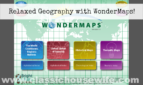
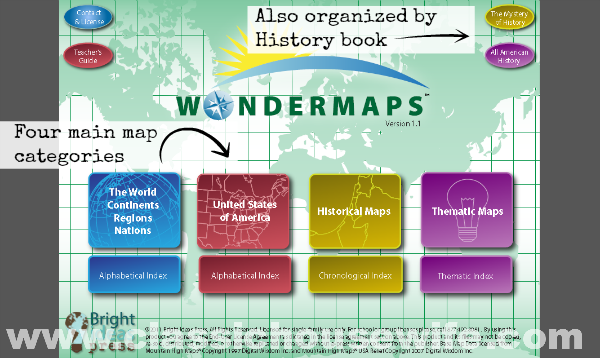
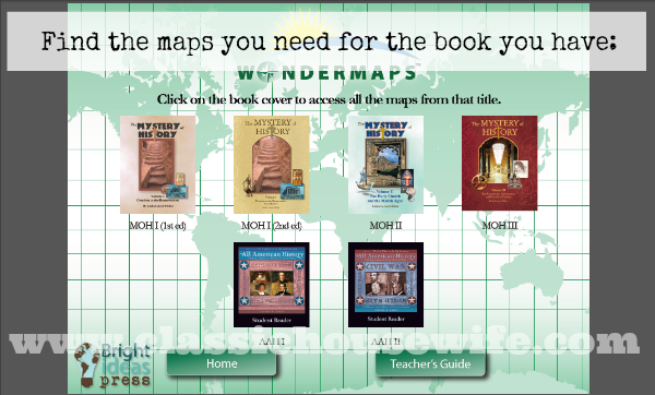
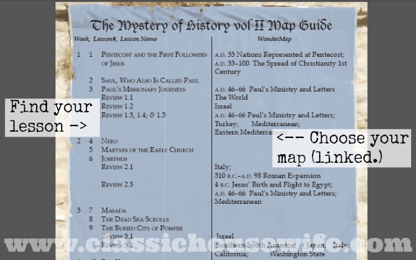
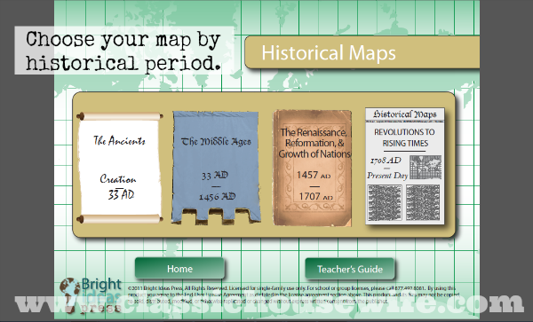
1.) Maps for Mystery of History lessons. While they have a ton of maps organized by world, U.S., historical time period, and theme – it was the fact that they also have maps organized by The Mystery of History lessons that really caught my eye. Instead of finding the map at the back of the book and making a copy, I can pull it up on the computer by lesson number and print it out — WITH a variety of printing options, too. (See next item.)
2.) LOTS of printing options. Before printing a map I can choose to add or take away things like color, typography, political boundaries, capitols, cities, rivers, and so on. I can tailor the map for my purpose.
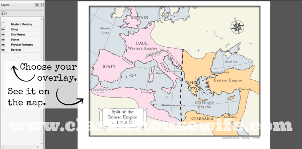
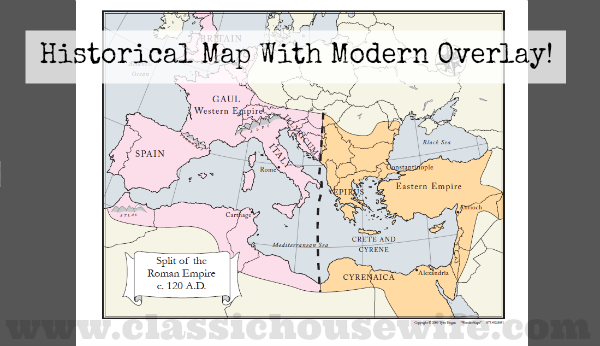
3.) Modern overlay. For many (but not all) of the historical maps you have the option to add a modern overlay. For example, while viewing the map for the split of the Roman Empire, you can view both the color historical overlay and add an overlay with today’s modern boundaries.
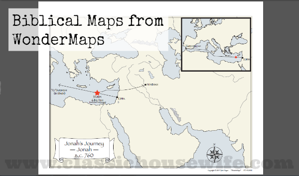
4. All the maps I’ll ever need in one resource. I am additionally excited about a large number of biblical maps included. Want to see a map of Jonah’s journey? No problem.
So, WonderMaps is now a staple on our (digital) homeschool shelf. It will help us as we go through our Mystery of History, AND our American History (with the Homeschool Legacy unit studies.) We’ve been using it and I really like it.
P.S. WonderMaps is a software that you can buy on cd, or you can download it like I did. If you purchase the digital version you can download it immediately. It’s good to know that if you have trouble installing it (like I did,) the Bright Ideas Press team is super helpful getting you all hooked up. Also, if you’re worried about losing your digital purchases, don’t let that stop you! Here are some tips for digital purchases and if you lose your software, Bright Ideas Press can help you get another.
Also, WonderMaps doesn’t run in it’s own application but runs in Adobe Reader. I know, it sounds weird, but it works. You should also know it works with Foxit Reader, too. (I know because that’s what I have, and I’m brave and I wanted to try it. I also downloaded Adobe to compare the two and see if there was a difference but the difference was minimal!)
Full Disclosure: Here’s that disclaimer about being a Brand Ambassador turned voluntary promotor. What does that mean? It basically means that I was”hired” to try out the product and share my experiences with you. Pretty neat, huh? You should know that *I* chose the WonderMaps product myself, that I wanted to use it, and that I use it still. I wasn’t hired to do a review, only to share it as I use it- like letting you watch me try it out. And although my “time is up,” so to speak, I still carry that title voluntarily. I promote WonderMaps because it’s the kind of product that any homeschool can use for the entire lifetime of their homeschooling experience; it’s a wise investment. If you have any questions for me about the WonderMaps product, ask! I will find out, learn it, try it, and get back to you.


Thank you for your review. It was very helpful. I’ve seen that many people seem to like it, but with the cost I wasn’t sure if I really needed it more than the maps we already have. We are starting Mystery of History this year and plan on MOH 2 next year. Thank you for helping to explain what all is available with WonderMaps.
[…] We discovered WonderMaps a few years ago when I was a brand ambassador for them a few years ago. I’m not a brand ambassador anymore, but we still have and use the software. There are too many benefits of this software to include here in one paragraph, but I’ve written about WonderMaps before. Check out this detailed post to learn more about WonderMaps and it’s many wonderful features: WonderMaps for Relaxed Geography. […]
[…] WonderMaps for Relaxed Geography […]
Can the maps be printed larger than 8-1/2 x 11? We like to use large maps (11×17) for our homeschool and I’d like to know if they print well at that size? Thank!
I can’t say for sure, I don’t print anything bigger than 8.5×11. But I think that they would do well, I really do.
I know this is an old post but I see that you have a map of the split of the Roman Empire – that map is nowhere to be found in my Wonder Maps. Where is it? I actually have very few maps and was disappointed with my purchase. Maybe I am not seeing something?